
Bitterroot River Maps, Fishing Access & Resources
Bitterroot River Maps, Fishing Access Sites, and resources for the Bitterroot River, West Fork Bitterroot River, East Fork Bitterroot River, Blackfoot River, Upper Clark Fork River, Lower Clark Fork River
Bitterroot and nearby Rivers Maps and River flow resources
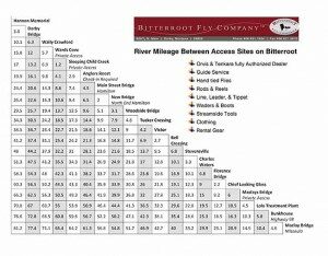
The Bitterroot Valley is ringed by rivers. Here are aids to help you navigate all the water available. Waters abound with west slope cutthroats, rainbows, cut-bows, browns, bull trout. We have big open water, small alpine streams and all in between. The valley is so trout bountiful it can be confusing. Where to fish? How to fish? What to fish with?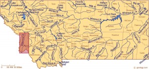 Use our river maps, access, and resources. See the general river relationships. The access maps show legal river entry points. In Montana, the state owns the rivers to 3 feet above the high water line. Off the river, you can not cross private land without permission. The on river mileage lets you plan your wade or float. Great for timing an outing. A major hatch chart for the Upper Bitterroot Valley is shown. The chart gives approximate months each hatch occurs. It suggests flies that show good results during each hatch. Hook size is also recommended. Many fly fishermen are surprised at how big the hooks are that our fish hit.
Bitterroot on River Mileage
 All the River Access maps are in pdf form, they enlarge when clicked on. In addition, they are printable to take with you traveling through the valley or on the river. The fish and scenery photographs are selected to show the average you can expect. Not the biggest or the most spectacular. All the resources are a general view and the weather and water flow plus level will affect the data, sometimes greatly. Stop by the shop, e-mail or call us for specific real-time conditions. We will be happy to share whatever information we have, and since we have guides on the river daily it is based on particulars, not a rumor
Bitterroot River Hatch Chart
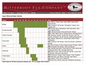
A major hatch chart for the Upper Bitterroot Valley is shown. The chart gives approximate months each hatch occurs. It suggests flies that show good results during each hatch. Hook size is also recommended. Many fly fishermen are surprised at how big the hooks are that our fish hit.
Darby Bridge cfs

CLICK MAPS TO ENLARGE
West Fork cfs

Bell Crossing cfs

Blackfoot at Bonner cfs

Clark Fork cfs above Missoula

Clark Fork cfs Below Missoula
